Contents
| 2.5 Web Map Service | Contents |
Web Service is a service available over the Internet, which uses a standardized XML-based messaging system. Web Services are integral to the interoperability of software applications, that is to say, Web Services support the exchange of otherwise independent web applications by way of a standardized interface. Web Services operate independent of existing programming languages and operating systems [Mitchell 2005].
Web Services are becoming very popular in web mapping applications, where they have been described as the »future of web mapping« [Mitchell 2005].
The so-called Web Map Services (WMS) allow for a smooth integration of different (raster or vector) maps in web mapping applications over the Internet. In this process, the role of displaying the map is performed by a
Web Map Server (WMS Server) [Erstling u. Simonis 2005].
A Web Map Client is the system which integrates the WMS, either server-side (e.g. in a map server) or client-side (e.g. in a web mapping application).
In a server-side WMS integration individual Web Map Services are cascaded, ie. several Web Map Services are integrated into one. The resulting linkages (or chain) act as a single WMS, ie. the chain is not visible to the user. The disadvantage of this arrangment is that the speed of map display in the browser will be determined by the slowest WMS in the chain. Another problem area: if one WMS in the chain is disabled, the web map client does not receive a response and the map area remains empty [Erstling u. Simonis 2005]. Here the map server takes on the role of the web map client.
During a client-side WMS integration the web mapping application requests the maps directly from the web map server and then displays these in the browser. When using several Web Map Services, each WMS can be displayed as a layer in the application. In this case the browser, ie. the web mapping application, acts as the web map client.
If only external Web Map Servers are used, the web mapping application does not really require its »own« map server since the extensive map generation process is shifted to the WMS server. Still, quite a few (Free) web mapping applications are designed to include their own map server (more on this in Chapter 3.1).
When a Web Map Service fulfills the WMS specifications9 of the OGC, it is referred to as a OGC conforming WMS. This means that requests to and responses from the WMS must be done according to a specific standard. The following three queries fall under current OGC specifications (with the third being optional)[Erstling u. Simonis 2005][Simonis u. Merten 2004]:
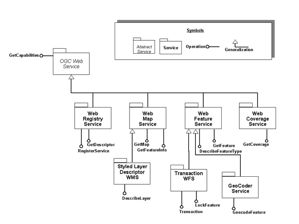
Figure 2.5.2 illustrates the relationships between some OGC web services, as well as the main operators (as defined by the OGC web services).
© June 1, 2007 |
Emanuel Schütze |
some rights reserved.
This work is licensed under the Creative Commons License
Attribution-ShareAlike 2.0 Germany.
| 2.5 Web Map Service | Contents |